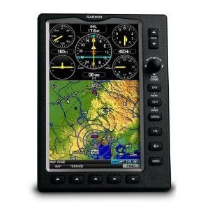
GARMIN 695/696航空(kōng)GPS 佳明(míng)高(gāo)明(míng)
- 産品品牌 GARMIN
- 産品價格 28000
- 産品描述
GARMIN 695/696航空(kōng)GPS,佳明(míng)航空(kōng)GPS696695,高(gāo)明(míng)航空(kōng)GPS696695,...
國內(nèi)通(tōng)航飛機使用最多(duō)的GPS。
Garmin GPSMAP 695 Color Aviation GPS
 |
GARMIN GPSMAP 695 |
商品規格
- 産品描述
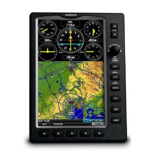
- 重要功能是航空(kōng)導航和(hé)測繪,GPSMAP 695是Garmin的極緻便攜的多(duō)功能航空(kōng)導航設備。 GPSMAP 695配備了大(dà)屏幕和(hé)詳細的電(diàn)子海圖,價格較有(yǒu)優勢,性價比高(gāo),你(nǐ)一定會(huì)喜歡。
( With features that focus on aviation-only navigation and mapping, GPSMAP 695 is Garmin's ultimate portable MFD. Similar to the 696, the GPSMAP 695 comes with a large screen and detailed electronic charts — minus XM compatibility — at a price you'll love. )
- 查看大(dà)圖
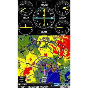
- 對GPSMAP 695的明(míng)亮的7英寸高(gāo)清晰度的陽光下可(kě)讀顯示詳細的映射容易看到白天或晚上(shàng) - 你(nǐ)甚至可(kě)以查看大(dà)幅面顯示屏上(shàng)的整個(gè)做(zuò)法闆。在屏幕上(shàng)的擋闆,便于操作(zuò),包括軟鍵和(hé)操縱杆控制(zhì)。一個(gè)5 Hz的快速GPS更新速率,695呈現的圖形,并提出飛行(xíng)數(shù)據順利并不斷。
(The GPSMAP 695's bright 7-inch diagonal high-definition sunlight-readable display makes detailed mapping easy to see day or night — you can even view an entire approach plate on the large-format display. For easy operation, the bezel around the screen includes soft keys and a joystick control. And with a fast 5 Hz GPS update rate, the 695 renders graphics and presents flight data smoothly and continuously. )
- 沒有(yǒu)紙圖?沒有(yǒu)問題的。
- GARMIN FliteCharts ®和(hé)IFR地圖模式此外,對GPSMAP 695提供關鍵功能的一類1/Class 2電(diàn)子飛行(xíng)包(EFB),減少(shǎo)在駕駛艙內(nèi)使用紙質海圖。随着FliteCharts,可(kě)以快速查找并查看所有(yǒu)美國NACO離場(chǎng)程序(DP)的,标準終端到達路線(星),方法圖表和(hé)機場(chǎng)圖。
(With the addition of Garmin FliteCharts® and IFR map mode, the GPSMAP 695 provides key functions of a Class 1/Class 2 electronic flight bag (EFB), reducing the use of paper charts in the cockpit. With FliteCharts, you can quickly find and view all U.S. NACO departure procedures (DP), standard terminal arrival routes (STARs), approach charts and airport diagrams. If the current approach is known, GPSMAP 695 automatically selects the correct chart based on the flight plan. When in IFR map mode, the 695 can display victor airways, jet routes, minimum enroute altitude and leg distance, much like what is found on paper enroute charts. )
- 像其他便攜式Garmin的設備,695包括以下增強航空(kōng)數(shù)據庫:
(Like other portable Garmin devices, the 695 includes the following enhanced aviation databases: )
- - Garmin的SafeTaxi ® (- Garmin SafeTaxi® )
- - AOPA機場(chǎng)指南 (- AOPA Airport Directory )
- - 私人(rén)機場(chǎng)和(hé)直升機場(chǎng) (- Private Airports and Heliports )
品牌:Garmin
- 型号:GPSMAP-695 )
- 尺寸:5.7”寬x 7.7”高(gāo)x 2.0”厚(14.5 X 19.5 X 5.1厘米)
- 重量:含電(diàn)池組1012克;不含電(diàn)池361克
